 About CPRE London
CPRE London is a leading environmental charity that campaigns to protect the capital’s green spaces, to strengthen their value for people and planet, and to ensure new development is socially and environmentally sustainable. Their vision is that by 2030 London has become a well-planned, greener, climate resilient and nature rich city, which benefits everyone. CPRE London supports many local campaigns to protect green spaces, runs seminars and publishes policies on topics such as threats to parks and greening London’s streets. They are also implementing the London Tree Ring, and planting new hedges, to add new woodlands, creating a mosaic of green habitats, to give the city an orbital wildlife corridor.
The request
London boroughs are required to plan access to parks and green spaces. In doing so, they measure how far households are from the nearest green space, and thereby identify ‘Areas of Deficiency’ (AoDs). CPRE London is concerned this system fails to expose areas where a lot of households rely on a small amount of green space, since it does not take into account the amount of green space available per person. For example, some parts of London have experienced extensive new high rise housing development, and the new residents might now all be reliant on what was already a busy park. The request to the Statisticians for Society volunteer was to find a way to present data to compare how ‘AoDs’ would look if population density were taken into account, i.e. if the measurement took into account ‘green space per person’ rather than just distance to a park or green space.
The approach
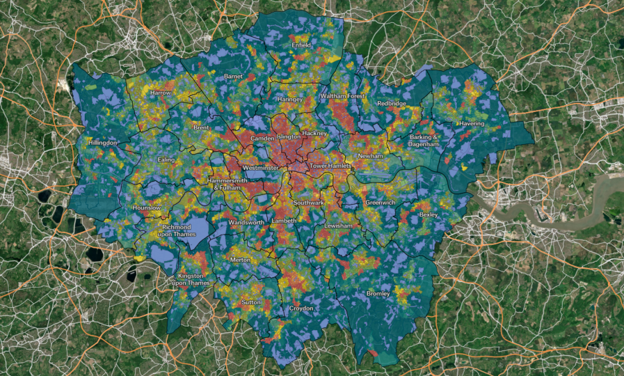
The charity shared the relevant data and their needs with the S4S volunteer statistician. Through active exchange with the charity contact, the volunteer developed a two-step method for calculating an index of green space per person. First, a pressure indicator is calculated for each green space, in square metres per person, using the population of small administrative units within 400 metres of the green space boundary. Then, an average pressure indicator is calculated for each output area, creating an index of average green space per person in each small administrative unit. The resulting index was used to create an interactive heatmap.
The result
The new index highlights previously ‘invisible’ areas of deficiency in access to green space when measured in per-person terms, particularly in parts of central London where population density is high. The interactive heatmap and accompanying explanatory notes were published on CPRE London’s website along with policy commentary. A webinar was also held to inform key stakeholders of the results, with high attendance and significant interest from the sector.
Impact and benefits
The results were submitted as a contribution to the Mayor of London's "Towards a New London Plan" consultation, and have since been mentioned prominently in the London Assembly Environment Committee report "Parks: Under pressure". Going forward, these results will support advocacy work by CPRE London to push for better planning and prioritisation of new parks and green spaces, benefitting those most in need. Notably, CPRE London is advocating for the conversion of streets into parks, and for bringing landbanked or disused Green Belt and Metropolitan Open Land sites back into use.
Volunteer: Gessienne Grey

Charity contact: Alice Roberts